
We’ve all had dubious advice from our sat-navs and smartphone maps, sending us to places we really don’t want to be via routes we’d never have chosen, but whilst researching options for my trip I’ve stumbled on one that really takes the biscuit.
One part of my journey across Canada that I’ve been particularly looking forward to is the chance to visit Prince Edward Island, or PEI as it’s known. It’s the home of one of the great characters of Canadian fiction, Anne of Green Gables, and a very beautiful island with stunning villages and beaches.
My plan has been to stop at the huge sea-bridge, Confederation Bridge, and board the free bus service to the island provided for cyclists, which protects us from the violent cross-winds that make it such a perilous journey. It’s actually illegal for bicycles to use the bridge, and you can see why:

So I located the bridge on Googlemaps and entered my destination as Cavendish Campground on the north coast of the island, near the Anne of Green Gables house. The map was on the “car” setting, and gave me the quickest route: so far, so good.
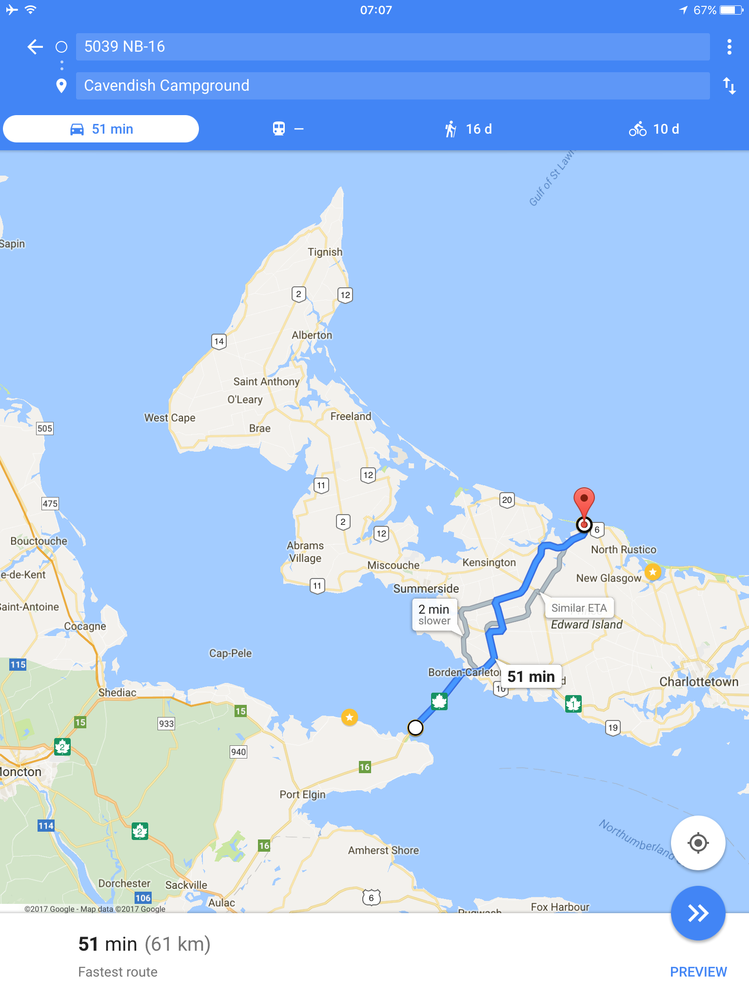
This looked fine, but I then noticed that next to the little bike symbol there was the journey time of “10d”, or 10 days. Thinking that this could not be right and assuming that it was a small glitch, I clicked on the recommended bike route. This is the route that Google has concluded will get me to PEI the quickest, by bike, from the start of the bridge:
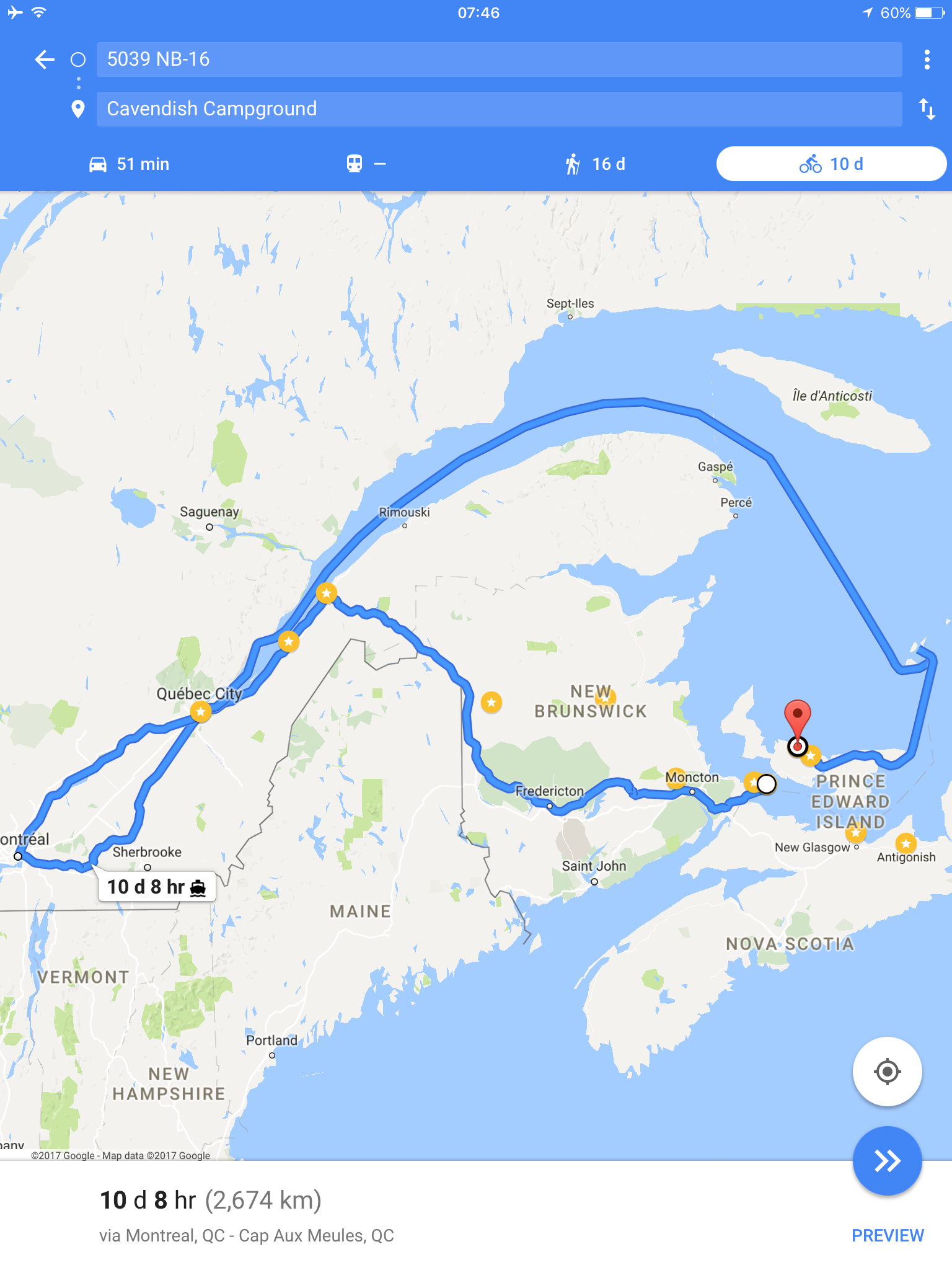
So, stage one is to cycle 695-miles all the way back to Montreal, from where I should board a ferry at Quay Jaques Cartier and begin a 6-day voyage up the St Lawrence River. Once out in the Gulf of St Lawrence, the boat visits the small island of Cap-aux-Meules before finally making landfall at the PEI port of Souris, a journey of a further 858 miles. From there it’s a quick 73-mile cycle back across the island to my campsite. Total distance: 1,661 miles, or 1/3 of the distance across the whole of Canada.
You can try this for yourself – it works every time. I suppose that someone forgot to tell GoogleMaps that the bus/bike service exists, and that there’s an alternative short ferry journey back to Nova Scotia available from Wood Islands in the south of PEI, which I’m planning to use as I leave the island. Of all the pitfalls and problems my journey presents, maybe unreliable technology is the one I should be most wary of.
Anyone else’s ridiculous routes from Google gratefully received.

London to Presteigne on the Welsh border. M40, M42, M5… so far so good. Carry on down the M5, go east on M4 to bristol, turn around at the roundabout, west on the M4, over the bridge, then about 40 miles of small roads north. Bonkers. The worst bit is we were so busy talking we didn’t realise it til we were at the M4!
LikeLiked by 1 person
Haha! Classic. At least I won’t have anyone to talk to, except those pesky voices in my head.
LikeLike